Trekking in Nepal 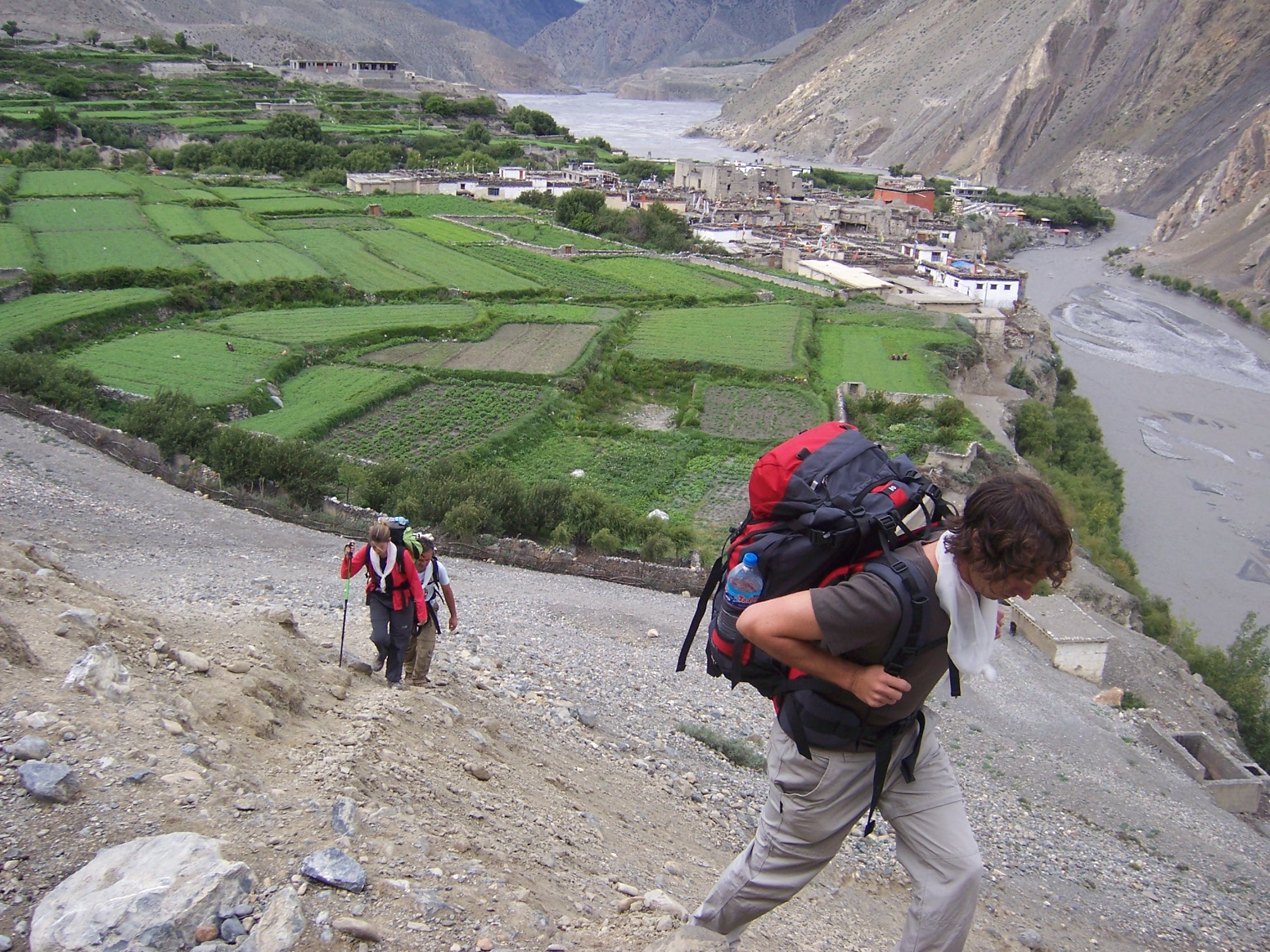 |
| Jomsom Trek, Jomsom Muktinath Trek , About pilgrims Muktinath, trek in Jomsom areas, holy places muktinath , muktinath darshan. |
Max.elevation : 3800m
Type of trek : Easy+Moderate
Duration of day : 5-12days
Duration a day walking:5-6 hours
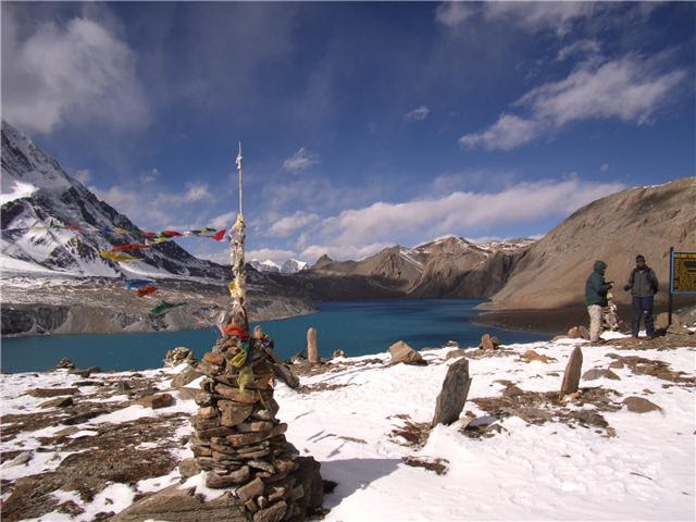
The Jomsom and Muktinath trekking in Nepal, is a part of the Annapurna circuit and perhaps the single most popular trek in Nepal. The diverse landscapes and cultures found along this trekking route give the perfect insight into the rural life of Nepalese people. The main feature of this trek is walking through the gorge carved by the Kali Gandaki River, which, carries water from the Tibetan plateau to eventually join the Ganges in India.
The starting and ending point is Nayapul about one hour drive from Pokhara. Normally trekkers continue on above Jomsom to Mukitnath, the famous pilgrimage site for both Hindu and Buddhist. To the Hindu, Muktinath is a sacred as the place of salvation. They believe that to wash in the water here guarantees salvation after death. To the Buddhist it is the place that the great sage Guru Rinpoche (Padmasambhava) meditated at, and to all, it is the source of fossilized ammonites, known locally as shaligrams that are found all along the upper reaches of the Kali Gandaki River valley. This trek is recommended year round as most of this trek is always in the rain shadow.
Itinerary:
(Please Note: If the above schedule does not meet your need and interest, I can design individualized travel plans based on your preferences.)
Day 01- Arrival in Kathmandu airport (1345 meters). There you will be met by our Airport Representative and transferred to hotel by private tourist vehicle. Overnight at your hotel with breakfast included.
Day 02- Sightseeing around Kathmandu valley.Your sightseeing trip will start at 9 AM in the morning after breakfast. You will be provided a private vehicle and professional tour guide. We visit Pasupatinath temple, Buddhanath, Monkey temple, Bhaktpur durbar square and Kathmandu durbar square. The afternoon includes a final briefing and preparations for the trek. Overnight at hotel.
Day 03- Drive to Pokhara (900 meters) 7 hours by tourist bus. Trekking staff will come to your Hotel at 6.30am in the morning to pick you up, 7 hour driving journey to Pokhara. Overnight at hotel.
Day 04- Drive to Nayapul (1010meters) and trek to Tikhedunga (1570meters) 3 hours We begin our trek at Nayapul after 1 hour driving by
private vehicle from Pokhara. After 15 minutes a short walk along the banks of the Modi Khola, we reach Birethanti (1015meters) a large village that has many shops and teahouses. From there, the trail continues through the village. The trail follows the north bank of the Bhurungdi Khola. Then the trail climbs steadily up the side of the valley to Hille at 1495m and after the short climb, we reach Tikhedhunga at 1570meters. Today’s walk offers a short and relatively easy day, during the journey which allows us to become used to the experience of trekking in Nepal. Overnight at guesthouse.
Day 05- Trek to Ghorepani (2840meters) 5 hours.Leaving Tikhedunga, we begin our journey with a steep climb to Ulleri. Ulleri is a large Magar village at 2070meters. The trail then continues to ascend more gently, through fine forests of oak and rhododendrons towards Banthanti at 2250meters. We trek towards Nangethanti at 2460m. After an hour of walk this brings you to Ghorepani at 2840meters. Overnight at guesthouse.
Day 06- Hike up to Poon Hill (3210meters) and trek to Tatopani (1190meters). 6 hours. It’s an early morning rise at 5 o’clock; we begin
trekking for Poon Hill. It takes an hour to climb from Ghorepani to Poon Hill, presenting you with one of the best Himalayan viewpoints in Nepal from where spectacular Himalayan ranges with amazing sunrise views can be seen very closely.
After observing the wonderful Himalaya views, we return to Ghorepani to have a hot breakfast. After breakfast, we continue our journey to
Tatopani.
The trail makes a steep descent to Chitre at 2390m. As the trail drops down through Sikha, the hills are extensively terraced. Sikha is a large
village with shops and hotels at 1980m, from there the trail descends gently to Ghara at 1705m. A further steep descent of 500m takes you to the Ghar Khola where the trail crosses the river on a suspension bridge. We then climb up above the Kaligandaki River before crossing too.
As you turn north, it takes you to the Tatopani at 1180m. Tato means ‘hot’ and pani is ‘water’, a name earned courtesy of the hot springs by the river. Tatopani is a popular short trekking spot just out of Pokhara. Overnight at guesthouse.
Day 07- Trek to Ghasa (2010 meters) 5 hours. Today, the trail climbs up the Kali Gandaki gorge, considered to be the deepest in the world which is situated between the two 8000meters peaks of Annapurna and Dhaulagiri. The trail rises gently up to Dana at 1400meters, and onto Rupse Chhahara at 1550meters, there you can see a stunning waterfall. As the trail crosses to the eastern bank of the river, you will reach Kopchepani which crosses back to the western side on a suspension bridge at 1935meters. Then a short climb to Ghasa at 2010meters. Overnight at
guesthouse.
Day 08- Trek to Tukche (2586m.) 5.30 hours. We start the trek by crossing to the eastern side of the river, but cross back again further up the
trail before entering Larjung at 2560meters. The trail continues on a short distance to the interesting village of Khobang with its narrow alleyways. Then we spend over night at the ancient Thakali village of Tukuche at 2590meters. Overnight at guesthouse.
Day 09- Trek to Kagbeni(2810m.) 5 hours. From Tukche, we climb along the side of the valley to Jomsom at 2713meters. Jomsom is
a large, bustling settlement and it’s the administrative centre to the region that contains the airport, army camp, hotels, shops, banks and government offices.
We cross the river to the eastern bank; then walk towards Eklai Bhatti at 2730meters. From here we take a direct route to Muktinath that ascends the hill behind the village, however we follow the trail along the river to Kagbeni at 2810meters which is situated at the junction of the Jhong Khola & the Kali Gandaki which is the northern most village that can be visited without a permit to continue on to Mustang. This village is fascinating with its rich Tibetan cultures and their unique hospitality which influences us greatly. Overnight at guesthouse.
Day 10- Trek to Muktinath (3802meters) 5 hours. We make a steep climb up the Jhong Khola valley leaving Kagbeni, we then join the direct trail to Muktinath just below Khingar at 3200meters. From here trail continues high above the Jhong Khola to the imposing village of Jharkot at
3500meters, well worth exploring. We take a break here for lunch before continuing on to Muktinath .As we leave Jharkot, the trail climbs up to our ultimate destination of Muktinath at 3802meters. We initially visit Ranipauwa, there are many teahouses and shops. Our overnight stay will be here. Further 10 minutes’ walks up the hill, we will be rewarded with the actual religious site of Muktinath & this area is kept free of hotels and camping sites. Muktinath is a pilgrimage center for Buddhists and Hindus. There we can see Tibetan traders as well as sadhus from the far south of India. There are shrines in a grove of trees including a Buddhists gompa & the Vishnu temple of Jwalamai. An old temple nearby shelters a spring and natural gas jets that provide Muktinath’s famous eternal flame. It’s the earth-water- fire combination that accounts for Muktinath’s great religious significance. Overnight at guesthouse.
Day 11- Trek back to Jomsom (2713meters) 5 hours. Today we follow the same trail nearby Kagbeni and then the new trek takes you down to the Eklebhatti, then again follow same trail to Jomsom. Overnight at guesthouse.
Day 12- Morning flight to Pokhara.Today 30 minutes morning flight takes us to Pokhara from Jomsom. Once we arrived at Pokhara airport, we then drive to hotel. In the afternoon we will have a sightseeing tour around Pokhara valley, which covers Fewa Lake, Devi’s water fall, Museum, Tibetan refugee settlement and Gupteshower cave etc. Overnight back at hotel.
Day 13- Leisure day and Sightseeing in around Pokhara. It's also spare day in case of bad weather in Jomsom. Overnight at hotel.
Day 14- Drive back to Kathmandu (1345meters) by bus or flight
Day 15- Transfer to international airport for your final departure. The trip ends, our Airport Representative will drop you to the Kathmandu international airport for your final flight departure from Nepal.
For more details ,contract: Tulasi Ram Paudel
Mail: tripnepal46@gmail.com / tulasip@hotmail.com
websites:www.trekguidenepal.weebly.com
Mobile or whatapp:00977-9846058846
Tripadvisor: Professional freelancer trekking guide in Pokhara, Nepal https://www.tripadvisor.com/Attraction_Review-g293891-d4722808-Reviews-Professional_Freelancer_Trekking_Guide-Pokhara_Gandaki_Zone_Western_Region.html
 |
| Jomsom Trek, Jomsom Muktinath Trek , About pilgrims Muktinath, trek in Jomsom areas, holy places muktinath, muktinath darshan |
 |
| Jomsom Trek, Jomsom Muktinath Trek , About pilgrims Muktinath, trek in Jomsom areas, holy places muktinath, muktinath darshan |
 |
| Jomsom Trek, Jomsom Muktinath Trek , About pilgrims Muktinath, trek in Jomsom areas, holy places muktinath, muktinath darshan |
 |
| Jomsom Trek, Jomsom Muktinath Trek , About pilgrims Muktinath, trek in Jomsom areas, holy places muktinath, muktinath darshan |
 |
| Jomsom Trek, Jomsom Muktinath Trek , About pilgrims Muktinath, trek in Jomsom areas, holy places muktinath, muktinath darshan |
 |
| Jomsom Trek, Jomsom Muktinath Trek , About pilgrims Muktinath, trek in Jomsom areas, holy places muktinath, muktinath darshan |
 |
| Jomsom Trek, Jomsom Muktinath Trek , About pilgrims Muktinath, trek in Jomsom areas, holy places muktinath, muktinath darshan |
 |
| Jomsom Trek, Jomsom Muktinath Trek , About pilgrims Muktinath, trek in Jomsom areas, holy places muktinath, muktinath darshan |
 |
| Jomsom Trek, Jomsom Muktinath Trek , About pilgrims Muktinath, trek in Jomsom areas, holy places muktinath, muktinath darshan |
 |
| Jomsom Trek, Jomsom Muktinath Trek , About pilgrims Muktinath, trek in Jomsom areas, holy places muktinath, muktinath darshan |
 |
| Jomsom Trek, Jomsom Muktinath Trek , About pilgrims Muktinath, trek in Jomsom areas, holy places muktinath, muktinath darshan |
 |
| Jomsom Trek, Jomsom Muktinath Trek , About pilgrims Muktinath, trek in Jomsom areas, holy places muktinath, muktinath darshan |
 |
| Jomsom Trek, Jomsom Muktinath Trek , About pilgrims Muktinath, trek in Jomsom areas, holy places muktinath, muktinath darshan |
 |
| Jomsom Trek, Jomsom Muktinath Trek , About pilgrims Muktinath, trek in Jomsom areas, holy places muktinath, muktinath darshan |
 |
| Jomsom Trek, Jomsom Muktinath Trek , About pilgrims Muktinath, trek in Jomsom areas, holy places muktinath, muktinath darshan |
 |
| Jomsom Trek, Jomsom Muktinath Trek , About pilgrims Muktinath, trek in Jomsom areas, holy places muktinath, muktinath darshan |
 |
| Jomsom Trek, Jomsom Muktinath Trek , About pilgrims Muktinath, trek in Jomsom areas, holy places muktinath, muktinath darshan |
 |
| Jomsom Trek, Jomsom Muktinath Trek , About pilgrims Muktinath, trek in Jomsom areas, holy places muktinath, muktinath darshan |
 |
| Jomsom Trek, Jomsom Muktinath Trek , About pilgrims Muktinath, trek in Jomsom areas, holy places muktinath, muktinath darshan |
 |
| Jomsom Trek, Jomsom Muktinath Trek , About pilgrims Muktinath, trek in Jomsom areas, holy places muktinath, muktinath darshan |
 |
| Jomsom Trek, Jomsom Muktinath Trek , About pilgrims Muktinath, trek in Jomsom areas, holy places muktinath, muktinath darshan |
 |
| Jomsom Trek, Jomsom Muktinath Trek , About pilgrims Muktinath, trek in Jomsom areas, holy places muktinath, muktinath darshan |
 |
| Jomsom Trek, Jomsom Muktinath Trek , About pilgrims Muktinath, trek in Jomsom areas, holy places muktinath, muktinath darshan |
 |
| Jomsom Trek, Jomsom Muktinath Trek , About pilgrims Muktinath, trek in Jomsom areas, holy places muktinath, muktinath darshan |